-
 play_arrow
Kl 1 Radio Local radio for west Norfolk
-
 play_arrow
KL DISCO KL Disco Playing Disco Music from the 70's onwards.24/7
-
 play_arrow
KL COUNTRY KL COUNTRY Playing New and Classic Country Music 24/7
-
 play_arrow
KL ROX KL ROX The best of New and Classic Rock.24/7
-
 play_arrow
KL SUMMER Summer Vibes 24/7 from KL1 Radio across West Norfolk
-
 play_arrow
KL CLASSICAL Your Symphony Starts Here
-
 play_arrow
KL CHILL Just Chill!
-
 play_arrow
KL POP The Best POP Hits all day Long!
-
 play_arrow
KL XTRA KL XTRA
music_note
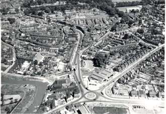
In the first half of the 19th century, it was the fastest-growing part of town. If people from that time could see it now, it would barely be recognisable.South Lynn has played a pivotal role in the history of our area. It has gone through industrial revolutions, been home to a booming whaling industry, and expanded significantly to house thousands of new residents.We’ve taken a deep dive into the story of this area, which was once one of four segregated localities along with North Lynn, West Lynn and Gaywood.
From churches and chapels to bypasses and burial grounds, the tale is a fascinating one…MEDIEVAL SOUTH LYNNAll Saints’ Church is the oldest building in all of Lynn, dating back to 1090 – making it nearly 1,000 years old.
It was rebuilt in the late Middle Ages, with the roof surviving from this period. The church’s tower collapsed in 1763, while one of its stained glass windows now forms the South Lynn War Memorial.It was originally part of the Old South Lynn parish, which was distinct from Bishop’s Lynn – as the town was called back then. The border was at Millfleet, which is now home to several blocks of flats. At this time, South Lynn began at the South Gate. Travellers would make a sharp left turn after going through the gate in order to reach the town centre – London Road did not exist.
AN AMALGAMATIONWithout a market to boost trade, the area remained a small community and remained so until it officially became part of Lynn in 1555.Even by 1668, South Lynn had just 52 households and much of it consisted of farmland and gardens. Dr Paul Richards, a historian who grew up in Old South Lynn who has also been a councillor and mayor in the area, knows the town better than most.“There’s two tales. It’s the Old South Lynn and the new South Lynn – extremely interesting in the history of Lynn,” he says.“You can’t sense it so much now, but Lynn was very fragmented essentially in West Lynn, North Lynn, South Lynn and Gaywood.“You would belong to one of them – you didn’t mix much.” Dr Richards recounted one particular story where an Old South Lynn worker visited a North Lynn tavern to court the women – but all of them immediately turned their backs on him.Sometimes, the men were even chased away for stepping into foreign territory.
HISTORIC BUILDINGS AND MONUMENTSSeveral locations which are close to the modern town centre form part of Old South Lynn.These include the Greenland Fishery, which was built in 1605 by John Atkin, who was twice the mayor of Lynn. Distinctive paintings on its walls date back to this time, and its name comes from its use as a tavern by crews of whaling ships travelling to Greenland.It became a museum in 1912, but closed down in 1941 after being damaged by bombs during the Second World War.Close to the old fishery lies the Whitefriars Gate – something of a miniature South Gate.
This is the only remnant of the Carmelite Friary, a living and working space for monks and nuns. It was founded in the 1200s and dissolved around 300 years later, with astronomers and mystic pilgrims among its members.BUSINESS WAS BOOMING Between the 16th and 19th centuries, South Lynn – the Harding’s Pits area specifically – was home to the town’s whaling industry.Ships were built, merchants and captains congregated, and traders worked at this location.This year, a new whale sculpture was unveiled at the Doorstep Green to pay tribute to these past connections.It replaced a previous wooden sculpture which had fallen into disrepair after 20 years of weather, vandalism and rot. After the whaling industry declined, the new South Lynn area played host to an industrial revolution which saw the likes of the Muck Works, a major artificial fertiliser factory, set up.When it closed in the middle of the last century, around 600 people lost their jobs.Perhaps the most impressive is the still-thriving Cooper Roller Bearings, which was established in 1894 and now conducts business across the world.It was set up by Thomas Cooper, a well-renowned engineer whose first major invention was a revolutionary steam digger for use in farming.
He invented the first small aerial bombs of their kind during the First World War, and at one stage he held more patents than anybody else in the country. However, it was the ground-breaking split bearing he invented in 1904 which forms the greatest part of his legacy. It quickly became the most well-used in the world.A second industrial revolution later resulted in the creation of the Hardwick Industrial Estate as town leaders sought a new way to get business booming again.“New South Lynn was a creation of Lynn’s first industrial revolution, whereas Old South Lynn was the creation of the town expansion of the early 19th century,” Dr Richards says.A HISTORIC ENTRANCE TO LYNN The South Gate remains, to this day, one of the most recognisable structures in Lynn. In fact, a huge masterplan to revamp the area in the coming years has a specific focus on it.
After being built, the South Gate was considered the most important part of the town’s defences, and was designed to impress visitors arriving from London.It was constructed using brick in 1438 with a bridge over the river, and it was clad in stone in 1520.Side passages, which can still be used, were added for people to walk through in the 19th century – and although many town gates have been demolished over the years, this one has remained in pride of place.The South Gate is located close to historic roads such as Southgate Street and Friars Street. These formed the original southern entrance into town, and used to be home to medieval inns such as The Dolphin and The Goat.
However, at the start of the 19th century, a new bypass would transform the town forever.A NEW ROUTE INTO TOWNLondon Road, now the main road into town from South Lynn – cue the complaints about rush hour traffic – was built between 1803 and 1806.This meant that traffic arriving at the South Gate no longer had to turn left to get into the town centre, and could instead travel along a new bypass lined with what were described as “handsome houses”.
This project had a transformational impact on South Lynn as a whole.Two years prior to London Road’s construction, 701 people lived in the area.Within 50 years, that number had risen to 4,731.Several buildings of public importance were therefore built along the road, including a hospital in 1835, a Methodist chapel in 1862, a tech college in 1895, and the Carnegie library in 1905.The road remains vital, leading to Railway Road and North Lynn as well as offering connections to Vancouver Avenue and Goodwins Road.AN OLD RAILWAY STATIONIn the 19th century, to support the growing industrial revolution, a railway station was introduced in South Lynn to help deliver materials to businesses setting up shop here.It opened for goods traffic in 1863, with passenger travel starting in 1886.Dr Richards says there used to be three trains a day which would travel from Great Yarmouth to Norwich, Dereham, South Lynn and then Peterborough, Leicester and Birmingham.However, that line became defunct in 1959. The railway bridge was demolished, with old newspaper clippings showing it plunging into the river.“That was a great loss,” Dr Richards says.Earlier this year, the creation of a new station south of Lynn was the centrepiece of a new strategy unveiled by the Eastern Powerhouse (EP).It would be located on the Lynn to London line and could be built on land off the A47 between South Lynn and West Winch.Updates have been scarce since the plans were announced, but residents’ hopes will no doubt be high that train travel could return to the area once again.DISASTER IN 1953The 1953 floods which claimed so many lives in West Norfolk were particularly hard-hitting in South Lynn.
On a single Saturday evening, 15 people in the area were killed as water in the River Great Ouse rose to more than 30 feet high.Newspaper reports from the time said that Wisbech Road and London Road quickly became “swirling rivers”, with families forced to take refugee in the upper floors of their homes.Police sped through the streets in an attempt to warn residents, but the water rose too quickly.Wisbech Road and the streets either side – such as Diamond Street, Hockham Street, Queen’s Avenue and Hillen Road – were said to have taken the worst blow.Churches were damaged, windows shattered, doors submerged in water and garages smashed in what was one of the worst disasters West Norfolk has ever seen.CEMETERIES AND BURIAL GROUNDSPerhaps one of the quirkiest places to visit in Old South Lynn is the Jewish cemetery.
The town used to be home to a significant Jewish population – its first synagogue was on Tower Street, with a later replacement on High Street.The cemetery on Millfleet was used for the most part by Dutch Jews who lived in the town from the mid-1700s until around 1846, before leaving when the area became less prosperous.Just last month, headstones and walls at the historic cemetery were repaired as part of a project to revive the site.Three headstones were repaired, while all of the Grade II-listed walls were treated with fungicide.Elsewhere, the last Quaker burial ground in the area could be found at Buckingham Terrace.It was located on land bequeathed by Thomas Buckingham, a ship owner, but was later leased as a garden and the memorials were removed.AN AREA ‘SPOILED’?Dr Richards remains unimpressed by the decision to build the Hillington Square flats off Millfleet in the 1960s, as to do this meant knocking down a number of historic buildings in Old South Lynn.He says that original plans would have seen “six Hillington Squares” built between Millfleet and Friars Street, but these were shelved.He adds: “As a kid, I knew it very well. It was a nice little area, with narrow streets – a lot of character was there. There was a brewery there.“That area was really spoiled by Hillington Square. I’m afraid that could have been a very much more desirable area.“I knew it so well and it took away a lot of our sense of identity.”Now, Mr Richards says there are plans for a music centre to be set up in the Greenland Fishery building – where, incidentally, a noticeboard detailing the history of Old South Lynn can be found.WHAT DOES THE FUTURE HOLD?Today, the newer area of South Lynn is largely home to houses. There are a few businesses such as convenience stores, takeaway restaurants and a post office – but no pubs.However, the Hardwick Industrial Estate is nearby – and in recent years, new business premises have been sprouting up off Nar Ouse Way as part of ambitious council schemes.As previously mentioned, the Southgates masterplan will also see that area transformed.“I think there’s lots of potential to grow and to be a pleasant place,” Dr Richards says.“I think you’ve got to be optimistic.”

Upcoming shows